
Stay up late—till 1am—to catch the colors of the sunset in mid-summer near Nome. Photo by Michael DeYoung
Travel Alaska all summer by car or RV, train, boat, and plane, and you’ll still only see a fraction of its 663,000 square miles. At more than twice the size of Texas, Alaska stretches nearly as wide as the contiguous United States. It takes all day to drive between Anchorage and Fairbanks, and a ferry ride up the Inside Passage from Ketchikan to Skagway spans over 24 hours. Two national wildlife refuges—Arctic and Yukon Delta—are each bigger than 10 other states.
Facts only go so far, though, in illustrating actual distance and its profound import; once you’ve traveled Alaska, the scope travels with you—hours behind the windshield as miles roll by; hundreds of photos devouring your phone storage; clothes you packed for sun, rain, and snow all in the same week; indigenous languages changing from Tlingit to Alutiiq to Aleut as you roam the Gulf Coast; hauling extra gas cans down isolated roads. What you experience in a month quadruples that visceral awareness. You’ll return not brimming just with knowledge, but rejuvenated with stories and a new appreciation of Alaska’s unique value in the world. ~Susan Sommer.
Rural Alaska road trip
“It is important to remember that driving in rural Alaska is unlike any experience in the Lower 48.”

“It is important to remember that driving in rural Alaska is unlike any experience in the Lower 48. While technically the ‘rules of the road’ still apply, it is also a common sight to see cars sharing the road with ATVs; children standing in front seats; and a lack of stoplights or signage signaling where, and when, to proceed. Vigilance is the watchword, and so is a reservation of judgment.
Nome’s roadways are limited to three highways, each totaling under 100 miles. They are narrow, made of gravel that can quickly turn to dirt (or mud, depending upon the season), and yet offer some of the most authentic views of Alaska. Look for sweeping vistas with few trees that are part of a centuries-old land bridge, or remnants of a bygone gold rush era. There are only a few options for renting cars (try aurorainnome.com/stampede-car-rentals), so if the cost is too high, or your confidence low, try a guided tour with Nome Discovery Tours, which often includes a guide in the form of Richard Benneville, Nome’s mayor and a true treasure of information and storytelling (nomediscoverytours.com).” ~Erin Kirkland, travel journalist, author of Alaska On the Go: exploring the 49th state with children, and publisher of AKontheGO.com
Alaska Highway road trip
“The Alaska Highway is the ultimate road trip, and it has some interesting route choices, especially in Yukon. One of those choices going north is to bypass Whitehorse and take the South Klondike Highway to Skagway, Alaska, the ferry to Haines, Alaska, and then drive the Haines Highway to Haines Junction, Yukon, where it intersects the Alaska Highway. With clear weather, this is perhaps the most beautiful drive in North America. The road from Carcross (meaning caribou crossing), Yukon, over White Pass to Skagway has everything: mountains, glaciers, waterfalls, movie settings (Never Cry Wolf), and it ends at the ocean.
It also, however, ends up in the summer cruise ship crowds that swarm Skagway. Fortunately, if you’re camping, there’s a great campground about nine miles out of town in Dyea, the historic beginning of the Chilkoot Trail. The Dyea Forest Service campground is situated next to a river, beautifully wooded, cheap, and uncrowded. Dayhikers can explore up the Chilkoot Trail as far as their legs will allow.
Haines is a short but beautiful ferry ride from Skagway. The Haines Highway is another almost numbingly beautiful drive, starting along the Chilkat River with Teton-esque mountains in the near distance. The road eventually climbs above tree line and reenters British Columbia and then Yukon. There’s a really nice hike at Chuck Creek, about 62 miles up the road—a great place to walk a dog or just yourself. The Village Deli and Bakery in Haines Junction is off the main highway, but definitely worth finding for brownies and carrot cake and other yummy stuff. It’s not like there are a lot of good places to eat in that part of the world, so it’s important to hit one when you can.
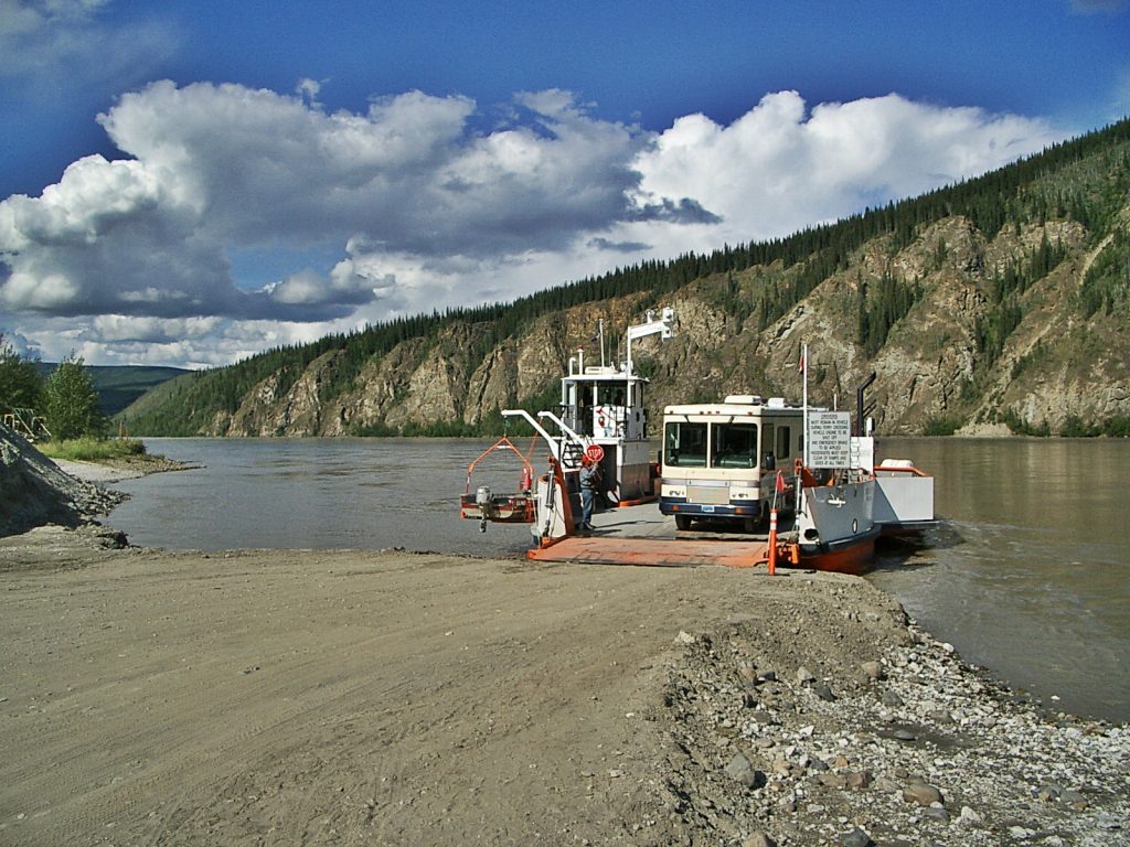
The second alternative route on the Alaska Highway is the Klondike Loop, which follows the North Klondike Highway near Whitehorse, Yukon, to Dawson City, then the Taylor Highway back to the Alaska Highway near Tok, Alaska. This detour is a must for anyone who ever read Jack London and dreamed of the Klondike Gold Rush. Dawson City is hard to believe given its extremely remote location and what it took to originally get there. I love the free car ferry that crosses the Yukon River in Dawson City to connect to the highway to Alaska. It’s a rush feeling the power of the river grab the ferry as it pulls out, hoping the engine doesn’t die and wondering what would happen if it did. On the opposite side there’s a very nice Yukon campground (Yukon has the best campgrounds—cheap with free firewood). There’s an unmarked paddle-wheel river boat graveyard about 100 yards down the river from the edge of the campground, where several river boats were grounded when they were no longer needed. It’s history slowly decaying into the ground, and one of the cooler things in an already very cool place.” ~Patrick Fort, Eagle River
Seward Highway
All great Alaska road trips must include a Subaru and a couple of wet dogs.
Susan Dunsmore

“All great Alaska road trips must include a Subaru and a couple of wet dogs. My favorite is to get on the Seward Highway, stop at Portage Lake for a short hike and the opportunity for the dogs to revert to their natural, dripping state. We pile back in the car and continue south, making a hard right onto the Hope Highway. Park at the trailhead and hike all or part of the 12-mile round trip to Gull Rock. The trail is easy and well-maintained, and offers beautiful views of Cook Inlet. If you like camping with dry dogs, the campground here offers flat ground, and there is a restaurant and bar in town so you can grab dinner and a beer. In the morning, continue south on the Seward Highway, and make a right onto the Sterling toward Homer. Homer is our destination, but it takes a while as we will stop at Kenai Lake, the Russian River, and I personally am incapable of passing Pizza Boys in Soldotna without stopping for a pizza (leftovers!). Once we make it to Homer, we check out the campground on the spit. If it’s too windy, we might opt for the Horniday Campground up on the hill but if I’m in the mood for a campfire on the beach and a walk along the ocean late at night, you’ll find me and a couple of damp dogs camping on the spit. Homer has a grocery store, and firewood is for sale at every gas station, so it’s a great place to spend a few days car camping without having to plan for an expedition before you can get on the road.” ~Susan Dunsmore, owner of arcticpups.com and former humor columnist for Alaska magazine
Comments are closed.